Date: 31/05/15 Position: Akaroa Harbour, Banks Peninsula
Well we were finally able to leave the clutches of Otago Harbour! Before leaving Otago Harbour we experienced another two bouts of storm force winds. One lasting for three days before it abated. The wind was recorded at 75 knots and the port was closed for three days. Once due to the strong winds and the other time due to a 7m swell breaking over the entrance sandbar. One morning we woke up to find snow on Ambler's deck and the beach and hillsides around us were white with snow. At the height of the second storm we dragged anchor with the strong winds during the night but luckily the anchor reset itself each time. The strong wind gusts ripping down the hillside caused Ambler to tack back and forth on its anchor which was very uncomfortable and felt like we were on a ride at a theme park. As you can imagine we had a few wild days and sleepless nights. There was a guy and his dog on a yacht anchored nearby but in the morning he was half way across the bay because his anchor hadn't reset itself like ours had. During a lull in the wind we went out to see if he was ok and found out that his engine didn't work, so we towed him back to a more sheltered position.
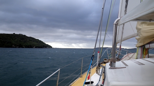
At last the opportunity arrived with a good weather window and the rough seas easing enough to make our escape and sail up the coast to Akaroa Harbour, Banks Peninsula. We covered 154 nm in 36 hours. 24 hours of that was motor assisted, sailing against a light northerly headwind. At sea we had two glorious days of sunshine in the company of many varieties of sea birds including lots of large Southern and Northern Royal Albatrosses. On the first day we were kept busy avoiding large rafts of seaweed obviously dislodged by the storms. We arrived in Akaroa Harbour at 8.30pm on Friday evening dropping the anchor in French Bay, just in time to sign off with Bluff Fisherman's Radio as it was the evening sched time.
Akaroa Harbour is the centre of an old volcano. The entrance is on the southern side of the peninsula. The water around us is jade green in colour and the green hills covered in farmland rise up to around 800m around the harbour creating a high, impressive circular skyline. The town of Akaroa is small and quaint with many old weather board cottages. It is a popular place for tourists and happens to be very busy this weekend as it is the Queen's Birthday long weekend.
Today was a beautiful sunny day so we went for a 'Country Walk' as they call it here. We walked from the town up through farmland following old stock routes to Stony Peak which is 860m high. It was a lovely walk with exceptional views from the peak of both the ocean and the snow clad southern alps in the distance. After descending 860m back to sea level we enjoyed another fantastic New Zealand ice cream which unfortunately was half the normal size because it was a tourist cafe.
All is wonderfully calm and still on board. Kathy and Wayne
----------
radio email processed by SailMail
for information see: http://www.sailmail.com
Sunday, 31 May 2015
A link to the current wind conditions around New Zealand
earth :: a global map of wind, weather, and ocean conditions http://earth.nullschool.net/#current/wind/surface/level/orthographic=-191.07,-40.89,678
Tuesday, 19 May 2015
Portobello Bay, Otago Harbour
Date: 19/5/15 Position: Portobello Bay, Otago Harbour, East Coat of the South Island (Dunedin)
We left the lovely, small, friendly Otago Yacht Club on Friday in cold, wet, blustery conditions. As we motored out of the protective break waters of the yacht club into the main harbour channel we realised just how windy it was. There was enough swell in the wind waves for Ambler to rock about and the tops of the wavelets were breaking. With the wind behind us we motored downstream. Every so often the view behind us was obscured as a rain squall passed over. Our intention had been to anchor at Carey's Bay, Port Chalmers but on considering the wind speed and direction and that apparently the holding is only fair at Carey's Bay we decided against anchoring there.
After consulting the chart and water depths there seemed one option open to us. Although Otago Harbour is large and extensive most of the bays and coves are very shallow. Ambler draws two metres so we went with option one which was to anchor on the leeward side of Quarantine Island. We were protected from the south west but there didn't seem to be enough safe swinging room with a few piles and reefs about. A friendly boatie who had the caretaker of Quarantine Island on board radioed us and said that the caretaker was happy for us to tie up alongside the wharf if we wanted to. It was a kind gesture but we didn't want to be banging against a wharf all night.
Unhappy with the limitations of this anchorage we consulted the chart again and realised we could find a safe haven in Portobello Bay. W weighed anchor and motored around the headland of Portobello Peninsula. As the tide was high we sounded our way into Portobello Bay and dropped anchor in the lee of the peninsula. Once we were happy that the anchor was set and holding nicely we peeled off our wet weather gear, went down below, closed the companionway door behind us and started the heater. The rain and wind continued outside but we were comfortable and dry in Ambler's cosy cabin.
The following morning the rain had cleared for us to appreciate the prettiness of Portobello Bay. The peninsula itself is covered in farmland with sheep grazing on the hillsides. There is a single cottage on the shore which doesn't seem to be inhabited. At low tide cormorants perch themselves about the exposed rocks airing their wings. Gulls and herons parade up and down the shore looking for food and flocks of flying geese fly in to land, heralding their arrival and departure with a polite honking. A road runs from the end of the peninsula along the shore of the bay to a group of houses huddled together on the other side of the bay. Behind the road are rising green hills dotted with farmland and small plots of pine plantations. Across the harbour from us is the shipping port of Port Chalmers which is well lit up at night. We have been monitoring the comings and goings of the ships on an App called Marine Traffic.
For the three days since we dropped anchor in Portobello Bay it has been blowing from the south west between 35-50 knots. Apart from the wind in the rigging almost driving us to the point of using ear plugs, it hasn't been too bad. We've been occupying ourselves with our various on board hobbies and generally having a relaxing time. We thought we may have been able to head north today as the wind had eased to SW 15 knots, but before we would have gotten very far the northerly of 20 knots would have kicked in. So we made the most of the calmer conditions and rowed the dinghy ashore and walked around the foreshore and over the hill to the tiny locality of Portobello. We were disappointed to find the nice, little shop/supermarket displayed no prices! It had a good selection of foodstuffs but after about our fourth trip to the counter to find the price of a product we realised why they obviously didn't have prices on anything. It was all very expensive. So we left with just one loaf of bread and two bananas.
On our blog there is a link to the Marine Traffic website. The website displays the locations and details of vessels that transmit AIS data. You can find Ambler on this website. When we first entered Otago Harbour a couple of weeks ago someone (a ship spotter) took a photo of Ambler from the shore. They posted a nice photo onto Ambler's details. Check it out if you like.
All is relaxed on board whilst we wait for a weather window.
Kathy and Wayne
----------
radio email processed by SailMail
for information see: http://www.sailmail.com
Wednesday, 13 May 2015
Photos of our cycle tour

Sunrise at Otago Yacht Club, Dunedin. Ambler is on the right.

Riding the Taieri Gorge Railway

A viaduct on the Taieri Gorge Railway

Riding from Pukerangi to Middlemarch, notice all the schist outcrops in the fields.

The start of the Otago Central Rail Trail, Middlemarch

A mother, daughter and sheep dog team rounding up the sheep on the trail.

One of a few tunnels we rode through.

The rail trail following the Taieri River
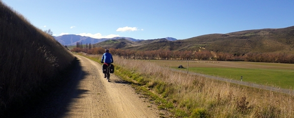
The Otago Central Rail Trail

The Otago Central Rail Trail

The Otago Central Rail Trail

The Otago Central Rail Trail

Us

Switchbacks on The Roxburgh Trail

Signage on The Roxburgh Trail

The Roxburgh Trail

The Roxburgh Trail

The Clutha Gold Trail

The Clutha Gold Trail

Letting sheep pass on the way to Waipori Falls
Tuesday, 12 May 2015
Cycle Touring
Date: 12/05/15 Position: Otago Yacht Club, Dunedin
We've spent the last five and a half days on our bikes riding a combination of the Otago Central Rail Trail, The Roxburgh Trail, The Clutha Gold Trail and an overland route back to Dunedin. We had four days of sunshine and a few challenging head winds at times and one day of solid rain. No mechanicals (bike problems) occurred and we covered 385km, averaging around 70km a day. Not bad considering we haven't been on the bikes for four months.
We thought with the good weather conditions and being able to leave Ambler safely at the Otago Yacht Club for a reasonable price it was too good an opportunity to miss. So last Thursday we caught the Taieri Gorge Scenic Railway from Dunedin to Pukerangi. It was a great trip which followed the Taieri Gorge through a stunning landscape. Once the train departed Pukerangi for its return trip to Dunedin, we found ourselves surrounded by open green farmland dotted with schist outcrops, an old station building and a solitary road which we thought must lead us to Middlemarch, 20km away and the start of the Otago Central Rail Trail.
We spent two sunny, windy days covering the 150km Rail Trail. The views were stunning with great open spaces of farmland dotted with sheep. We had to stop a few times and wait as farmers and their highly trained sheep dogs worked hard to herd sheep along the trail from one paddock to the next. High mountain ranges ran parallel to the trail as we wound our way alongside rivers flanked in willow trees. We passed through tiny, old townships that once supported the railway. As we neared Alexandra the countryside became dry, arid and rocky with a few tunnels, cuttings and viaducts to ride through and over. The trail climbed steadily in this area and we had great views of the sweeping countryside below. A local told us that Alexandra is like a desert with extreme temperatures in summer and winter and very little rainfall which results in poor soil and very little tree growth.
At Alexandra we left the Rail Trail and spent half a day on the highway as we headed to Roxburgh Dam. Again the scenery was breathtaking and never ceased to leave us in awe. The deciduous trees looked striking against the green fields and the weather remained sunny and cool. We completed part of The Roxburgh Trail, a purpose built 34km trail that runs along the dam with plenty of switchbacks as it climbs and descends. The beginning and end of the trail are complete but the middle section isn't as there are disputes with the landowner. However you can catch a boat for $95 to ferry you between the beginning and end if you wish too.
From the end of The Roxburgh Trail we joined The Clutha Gold Trail. This 75km trail followed the fast flowing, glacier coloured waters of the Clutha Mata-au River which flows from the Roxburgh Dam and Power Station. We spent a day and a half riding along this meandering and generally down hill flowing trail to Lawrence. We were constantly hearing and seeing a great variety of small birds along this trail. Often the trail was hidden under yellow and red leaves as we cycled through many groves of deciduous trees. With the river on our right, on our left could be seen a lot of evidence and history from the early gold prospecting days. We passed through a few small, tidy towns and noticed the landscape changing from the drier environment to lush, green sheep pastures.
On Monday afternoon after having lunch at Lawrence we set out to head back to Dunedin via Waipori Falls. This was a challenging ride after the cruzy trails so far with many steep climbs and descents. It was a lot more than we were expecting and not helped with the poor quality maps we had obtained from the information centre. The sky was laden with heavy looking dark blue clouds and the wind kept increasing. However we pedaled on and as we rode the final, very steep descent to Waipori Falls the rain began to fall.
It rained heavily overnight and remained constant all day today with a low temperature of 5 degrees. We rode the remaining 65km to Dunedin layered up with thermals, fleece and full wet weather gear. We only stopped once to refuel at a warm cafe otherwise we pedaled on to stay warm. With the thought of a hot shower waiting for us we reached Dunedin mid afternoon.
It was a fantastic cycle tour with amazing scenery and friendly locals.
All is warm again on board. Kathy and Wayne
Photos coming in the next few days.
----------
radio email processed by SailMail
for information see: http://www.sailmail.com
Tuesday, 5 May 2015
Photos en route from Stewart Island to Otago Harbour

A foggy morning at our anchorage at Millar's Beach, Patterson's Inlet, Stewart Island

A foggy morning at Millar's Beach, Patterson's Inlet, Stewart Island

The water monitor with our two 20 L water containers, Patterson's Inlet, Stewart Island

Ambler in the fog, Little Glory Cove, Patterson's Inlet, Stewart Island

Patterson's Inlet, Stewart Island

Golden Bay in the gentle rain and mist, Patterson's Inlet, Stewart Island

Getting ready for departure, Patterson's Inlet, Stewart Island
Heading out of Patterson's Inlet towards the Muttonbird Islands, Stewart Island

Buller's Albatross

White-Capped Albatross (Looks very similar to the Shy Albatrosses seen around Tassie)

Cape Petrel

Northern Royal Albatross preparing to take flight

Looking north towards Taiaroa Head and the entrance to Otago Harbour

Morning sun on Taiaroa Head

Susie and Richard on board 'Siapako' at the entrance to Otago Harbour

The lighthouse at Taiaroa Head. The Northern Royal Albatross colony is on the sloping headland to the right of the lighthouse.
Dunedin
Date: 5/5/15 Position: Otago Yacht Club, Dunedin
We left windy Stewart Island at 0900 on Saturday morning with a 25 knot westerly blowing. On sailing out of Patterson's Inlet we were presented with an eerie scene, with rays of sunlight filtering down through the dark, grey clouds ahead of us that were gathering over the outer lying Muttonbird Islands. As we sailed through these outer islands we were escorted by small Cape Petrels and both White-Capped and Buller's Albatrosses. After leaving the shelter of the islands we were exposed to the full force of the wind and waves coming through Foveaux Strait from the west. The wind was gusting up to 30 knots so we reduced sail down to just a partially furled headsail. It got quite rough at times with waves breaking onto the deck. But as we cleared the Strait and closed in on the East Coast of the South Island the wave action became smoother and the wind dropped to a nice, comfortable 15 knots and we set full sail again.
We continued sailing throughout the night taking three hour watches in turn. It was a beautiful evening with a full moon and good visibility. The wind stayed steady at 15 knots from the north west until it died away at 0600 and we were left to motor the remaining four hours to Taiaroa Heads. Sunday dawned with a colourful sunrise and the morning sun highlighted the colours and contours of the sheer, broken cliff faces of the headland with the rolling green hills of farmland beyond. There were large flocks of seagulls resting on the smooth surface of the sea with a few Cape Petrels and Royal Albatrosses standing out amongst them.
As we made our way over to the first of over seventy something channel markers that would lead us down the Otago Harbour to Dunedin we spotted our friends Susie and Richard on their motor vessel 'Siapako' leaving the harbour. We had a quick catch up on the water before they headed north. As we neared the headland of Taiaroa Head we could see white spots scattered amongst the green foliage. After looking through the binoculars we worked out we were seeing Northern Royal Albatrosses sitting on their nests at the albatross colony. We continued to motor down the harbour hearing and spotting several Little Blue Penguins along the way. The harbour channel reminded us very much of the Tamar Valley in Tasmania. It meandered its way along with green rolling hills on either side, broken by the colour of deciduous trees here and there. Occasional groups of houses were scattered along the waterfront until we reached the sprawling city of Dunedin at the end of the harbour.
We tied up alongside a floating pontoon which was adjacent to a building colloquial known as the 'Glasshouse'. We were only a 5 min walk from the centre of town and three major supermarkets. This was a great chance to do a major reprovision after four months. Being in port always seems hectic as we rush about getting this and that and trying to locate shops that sell what we need.
On Monday afternoon we left the pontoon and moved into the Otago Yacht Club, a small, tidy and friendly place still quite close to town.
All is full on on board with our waterline back down to where it was when we left Tasmania.
Kathy and Wayne
----------
radio email processed by SailMail
for information see: http://www.sailmail.com
Friday, 1 May 2015
Making the most of the bad weather
Date: 1/05/15 Position: Patterson's Inlet, Stewart Island
The last day that we had reasonable weather, we had a good walk from Oban to Horseshoe Point enjoying all the scenic qualities this peninsula walk offered. As the low cloud hung overhead the offshore islands could be seen in different shades of grey depending on their distance from us. Below us several fishing boats motored in and out on their way to Halfmoon Bay and small flocks of Gold Finches dipped and dived along in front of us. While we walked the weather stayed dry for us, but on returning to Oban the penetrating drizzle begun and the temperature started to plummet. From then on the weather just continued to deteriorate.
For the last five days we have been tucked away in an anchorage known as Sailor's Rest trying to hide from the constant storms and gales that have passed over us one after the other with winds between 35-50 knots. Sailor's Rest is recommended as the most protected all weather anchorage in Patterson's Inlet but with all things it has its limitations and is not as protected as it is made out to be. With a low lying hill to windward in south westerlies it meant that Ambler was totally reliant on its anchor set to the south west in shallow water. It was also too far to take a shore line to windward and this would have closed access to any other boats entering.
The wind has howled constantly in the rigging above us and Ambler has surged back and forth between her anchor and the stern line as blasts of wind have buffeted her about. The cause of all this bad weather is a result of several intense low pressure systems passing over us in a domino effect bringing with them frequent rain squalls. Just when we thought the wind was dying off and the conditions were calming down we realised it was only a lull before the next gale started ramping up.
Since the weather hasn't been conducive to kayaking or walking or even leaving the boat unattended in the strong wind conditions we have made the most of the weather by working our way through a growing list of boat maintenance jobs. One task in particular that we've been chipping away at for days is working on insulating any exposed areas of fibre glass in lockers, berths or in the cabin. This entails measuring and cutting pieces from our enormous roll of insulating material and using contact adhesive to glue it in place. It's been a good thing there's been a breeze about with all the fumes from the glue! In some areas we have double insulated with a second layer of insulating fabric. It's not until you come so far south that you realise how wet and drippy with condensation exposed fibre glass becomes which leads to things getting attacked with mildew.
Other jobs that have been ticked off are mounting a rope storage pouch in the cockpit to store the excess main sheet in, which always seemed to get tangled with everything. Stitching a bag together to store our collapsible crayfish pot in, sorting through our stores of onions and potatoes to separate the good from the bad and restocking our food containers in the galley from our long term supplies stowed under bunks, floorboards and any other space that could be found to put them securely before we left Tassie. Some bigger projects have been to work on assembling and installing the wind vane self steering system which has been in parts until now but which when installed will save energy as we won't need to use the auto pilot. An ongoing job in preparation for our arrival in Chile later this year has been to coordinate our scanned images of Chilean charts.
All is busy on board. Kathy and Wayne
----------
radio email processed by SailMail
for information see: http://www.sailmail.com
Subscribe to:
Posts (Atom)